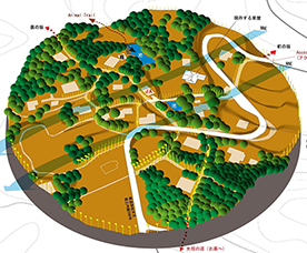
Brochure of the projects
消えた集落 ─ 閉村の碑からよみとくもうひとつの理由
昔はみんなたのしかった ─ 文化人類学手法によるフィールド・ワークから
English-Vanished village Kotsunagi in Matsudai
English-It was all fun in the past Kotsunagi in Tobitari-Nakajo
Français-Le village disparu Kotsnagi Matsudai
Français-Village de Kotsunagi Nakajo Tobitari
Introduction
There once was a village called Kotsunagi in Tokamachi City. I will explore the background leading to the closure of the “two Kotsunagi villages,” one in Matsudai and the other in Nakajo-Tobitari in Tokamachi, across the Shinano River. The place name “Kotsunagi” represents a key point in traffic routes connecting main roads with pathways or one village with another, and also a point where one descends from the mountain pass. The settlement is believed to have been located at a quiet point in the traffic.
The two villages were closed in 1992 and 2007, respectively, and the evidence of their existence spanning 400 and 800 years is preserved as “inscriptions” on the stele.
Both villages developed their histories and cultures by finding original ways of agriculture and life while adapting to the region’s natural environment. This distinctive agriculture and lifestyle of each community resulted in diversity that supported the ecology of the region while simultaneously improving adaptability to natural disasters and changes in the social environment.
The stele reads that people left the village one after another as they were influenced by “the Income Doubling Plan” advocated by the national government in the Showa era. Also, one can read in the inscriptions about the closure of the village how the consolidation of communal facilities in each district due to the grand mergers of municipalities in the Showa and Heisei eras led to the collapse of local communities and the decline of productivity in agriculture, making it impossible for communities to survive. This can also be seen in the trace of how the land had been used.
Under such circumstances, the Seeds and Seedlings Law has recently been amended to protect the intellectual property rights of seeds and seedlings. However, there are concerns about this movement as the law will make it difficult to maintain agricultural diversity, for example, by restricting the unique “home propagation” that farmers in each region have traditionally maintained. As the globalization of industry and economy progresses and the climate change issues become more apparent, it is important to reconsider the role of regional agriculture with diversity that has contributed to sustainable development.
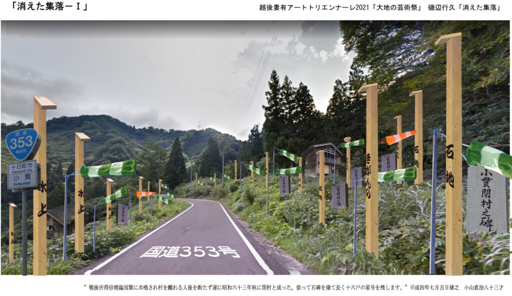
Vanished Village: Another Reason Hinted at the Stele of the Village Closure – Village Kotsunagi in the Matsudai Area
The name of the village, Kotsunagi, in the former Matsudai town, is believed to be a remnant of the small settlements that were scattered and nestled around a ridge that divided them into two, with a pass road in the center of the village. It seems that villages formed around the ridge road have been called so due to the topographical conditions. A lot of land on the slope means limited land for farming. In these landslide-prone sites with many slopes, irrigation channels become complicated, working conditions get harsh, and cultivation is restricted.
The limitation on cultivation naturally affects the economy, distribution, trading areas, transportation, and exchanges of the village.
Moreover, a village road between settlements that ran along Route 353 extended to the neighboring town as well as to Kashiwazaki City direction, revealing that the trading area spread towards the ocean in the Northwest. There is “a monument of the closed village” along Route 353.
The former village road or the present R353 runs along the ridge, and previous villages are connected to other villages along the road.
The seasonal northwesterly wind in winter is a distinctive climate characteristic of this area, which had a significant impact in winter close to the ridge in the villages.
The daily life of the village, such as cultivation and trade, may be restricted as a result of the snowfall.
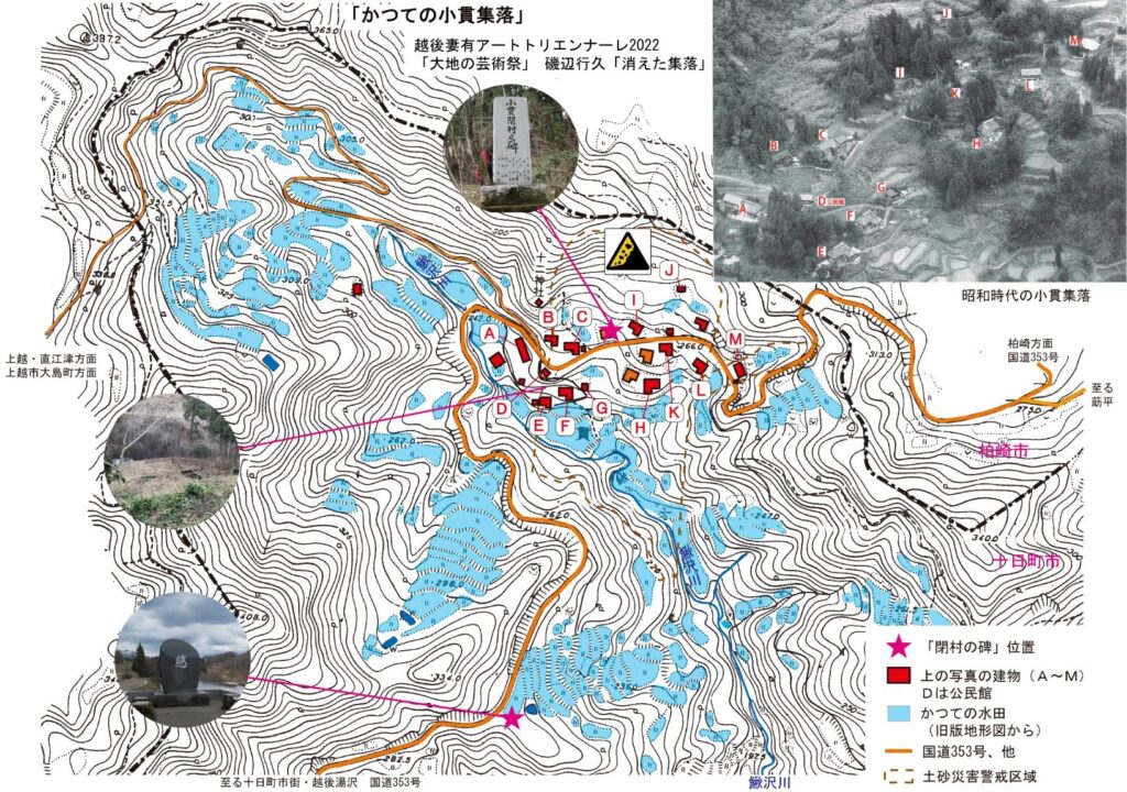
It is estimated that Kotsunagi village used to be centered on where the “monument of the closed village” stands along Route 353. The layout plan of the houses of the village is left behind, which clearly shows the positioning of the houses dotted on the slopes.
In between the houses were cultivated plots of land making use of the small flat land. Cultivation by farm horses and plowing of rice fields in 1960 and 1961 are captured in video footage, and one can see the hilly terrain, the site of a narrow plot of cultivated land, and the remains of a reservoir in the video.

The inscription on the “monument of the closed village” gives us insight into the conditions that this village was under, from natural environmental, regional, sociological, cultural, and economic perspectives. Furthermore, at the eastern end of the village stands the monument with only one character, “affection,” representing a wish for “protecting this land of grand nature and abundant green which was pioneered by the ancestor with everyone’s smile and sympathy.”
From there, we can get a glimpse of the long history of over a couple of hundred years, the cultural background of the village, and also the reason why the village couldn’t exist any longer.
For this installation, with two monuments of the closed villages at the center, I will set up four-sided pillars with the name of each family to represent the villages when they existed in the past. I will also install a streamer as a testimony to the northwesterly winter wind, which is considered to be one of the most characteristic of the region as well as the harshest natural phenomena.
I hope to express the course of history over the past four hundred years of “the vanished settlement” with the monuments of closed villages, trade names, streamers, land on the slope leading to Kajikazawa, and narrow cultivated land.
Botanical and Other Ecological Systems in the Village Kotsunagi in the Matsudai Area
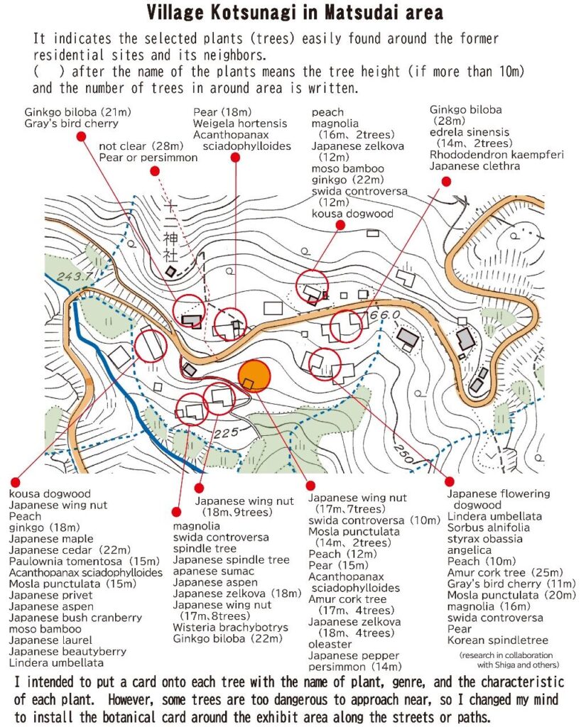
Animals and plants living in this area have contributed to the local people in various ways, and these creatures have constantly changed according to the changing activities of the locals.
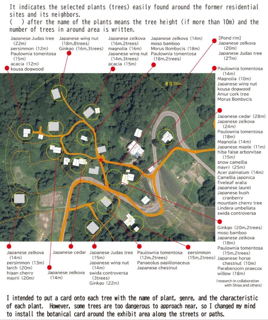
In the present Kotsunagi village, several plants can be found, including those for fuelwood or other woods, or plants for food or decoration, and also the increasing number of plants in abandoned fields and houses, or even planting.
This botanical situation reveals the environment, history, and culture of the area. Here introduced is the botanical distribution in the research of Mr. Takashi Shiga, owner of Shiga Teikaen, a gardening company of Tsunan-machi.
If we know such a botanical situation, then, we understand more deeply the environment, history, or culture of the locals.
The Chart Indicates The Model of the Possible Food Chain in Tokamachi Area.
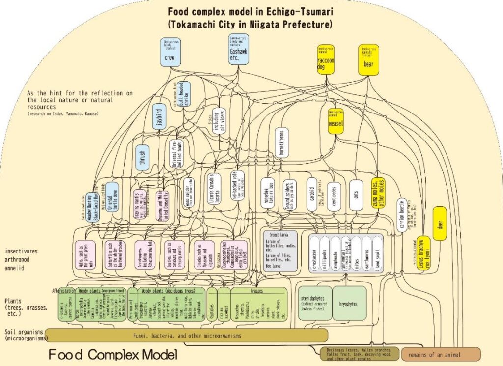
These models are also changing since the environment or its relationship with the people themselves has changed.
We hope that this chart will be a good reference to grasp the environment of the local people.


Videos from drone 1 (Matsudai)
It Was All Fun In The Past, from cultural anthropological fieldwork – Village Kotsunagi in Tobitari, Nakajo area.
Kotsunagi village in Nakajo・Tobitari underwent significant social changes. The Chuetsu Earthquake in October 2004 accelerated the depopulation of the village, which eventually led to its closure in 2007. Various communal facilities were established in the village throughout its long history, including the Agricultural Cooperative (Kotsunagi JA, 1958), shared workshops, clinics, fishponds, primary schools, communal hearths, shrines, farm roads, cemeteries, simple post offices, temples, water weirs for power generation, masonry bridges, plants (trees and tree species), and natural disaster responses (floods, earthquakes) and “epidemics” in the Meiji era, with their relation to the shrines.
This project aims to reveal how the villages were in the past; what facilities existed for the community, and the history of peaceful life in the village, through cultural anthropological research methods.
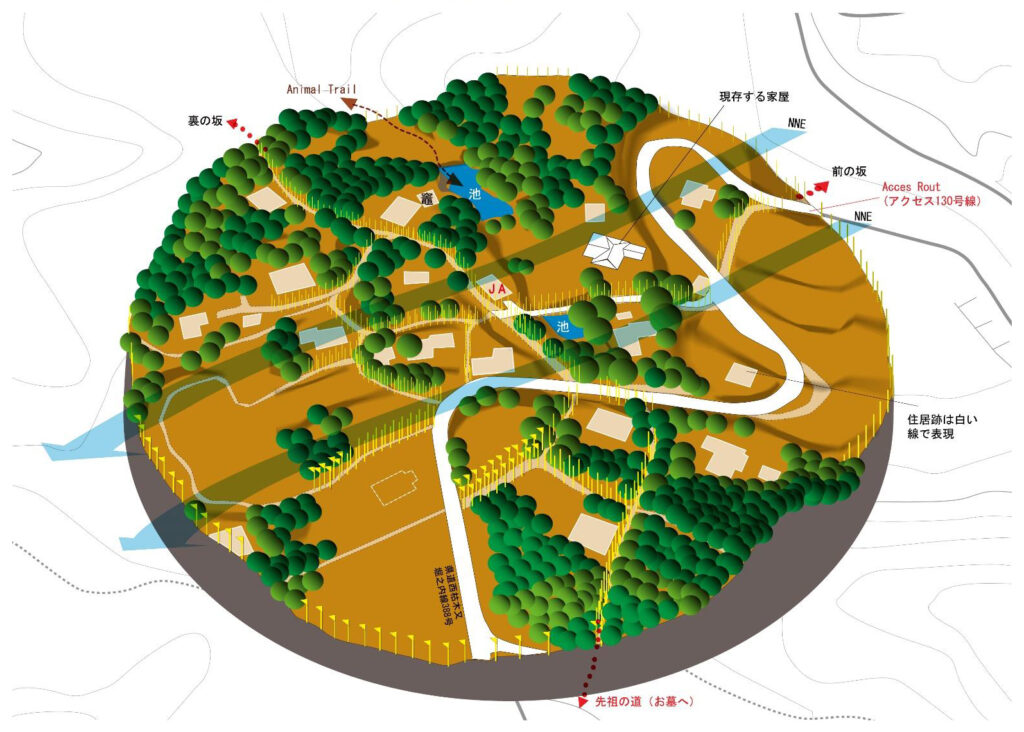
First, within a diameter of 300 meters of the site where the Agricultural Cooperative building, the center of the community and key facility of the economic and social life, once stood, we will expose the settlement’s bygone topsoil surface. The purpose of this research is to find traces of the old settlement and their lives from the exposed site, and consider why the village was formed and then closed here so that we could use our findings in the future. Close to the site where the Agricultural Cooperative stood is a trace of cracks in the ground caused by the Chuetsu earthquake that determined people leaving the village.
While we know most about the topography of the time, slopes, plants, paving stones, fishponds, cooking stoves, open spaces, temples and shrines, cemeteries, halls, remains of village roads, and the remains of cracks in the ground from the Niigata Chuetsu earthquake in 2004, we are planning to research many things that have disappeared through interviewing local people. To explore how the community existed, I used yellow poles tracing small pathways that were walked on by villagers every day. I couldn’t get clarity from the elderly members of the current village regarding the time of burial and cremation, a funeral custom, which indicates anthropological period classification. However, I managed to confirm there was a bone-eating ritual to inherit the wisdom of the ancestors as a funeral custom. There is a wide range of topics to be clarified by future research.
Botanical and other ecological systems in the village Kotsunagi in Tobitari, Nakajo area.
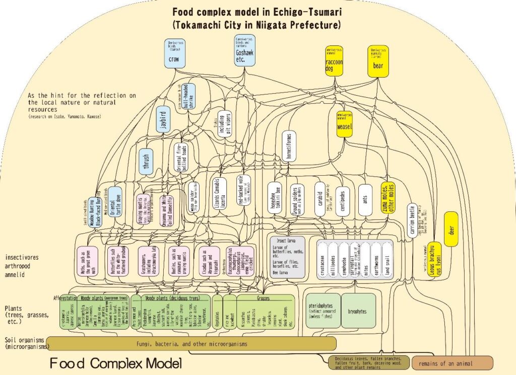
Animals and plants living in this area have contributed to the local people in various ways, and these creatures have constantly changed according to the changing activities of the locals. In the present Kotsunagi village, several plants can be found including those for fuel wood or other woods, or plants for food or decoration, and also the increasing number of plants in abandoned fields and houses, or even planting. This botanical situation reveals the environment, history, and culture of the area. Here introduced is the botanical distribution in the research of Mr. Takashi Shiga, owner of Shiga Teikaen, a gardening company of Tsunan-machi. If we know such botanical situations, then, we understand more deeply the environment, history, or culture of the locals. The chart indicates the model of the possible food chain in Tokamachi area. These models are also changing since the environment or its relationship with the people themselves has changed.
Welcome to Kotsunagi, introduction by Sanssei Niwano (former resident of the village Kotsunagi)
Thank you very much for your visit to Kotsunagi and its art installation entitled “It was all fun in the past” by Yukihisa Isobe. Kotsunagi closed itself in 2007, mainly because of the Niigata Chuetsu Earthquake in 2004, with the locals (3 houses) left there after staying and protecting the village to the last minute. It is to be noted that this was not a so-called “abandoned village” since the former residents still frequent their Kotsunagi for wild-vegetable-collecting or growing vegetables or rice in their fields. Also, there is the village Karekimata across the site of Kotsunagi, so the traffic with cars is still alive on the road.
To explain the village, Kotsunagi was composed of two parts: Kamimura (upper village) and Shimomura (lower village). If the origin of the village remains unknown, there were already 2 houses and 20 residents in Shimomura, according to the document, in 1692. Their family names were Harukawa and Niwano. Family Niwano had then increasing branch families in Kamimura.
In 1947, they counted 20 houses and 185 residents (135 adults and 50 children) in Kotsunagi, which was the peak in this village. 50 children in 20 families! While the declining birthrate is one of the serious issues in present society, this number of children is a surprising impact on our area of the baby bust.
It is important to remember in the history of Kotsunagi that the first JA cooperative was installed in the ex-Nakajo village. Also, the branch school during the winter season was built here in the latter period of the Meiji Era (1868-1907), since some residents could foresee the progressing society.
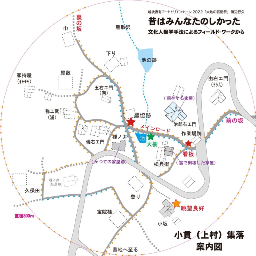
If you walk through Kamimura, you will know that the streets are located in a circle, with a compact layout of houses. It is better for stepping on the snow, an effective layout shared by the people to foot the streets with Kanjiki or against snow sandals. Thus, the locals managed to overcome the severe season of winter in cooperation with each other. We can reconsider the “spirit of balance or consensus.”
For this project, we carried out the mowing of grass or cutting scrubs and trees, recreating the local streets, and the credited yellow large poles were installed alongside. This pole was a good sign for strolling about in the village, so please try to stroll around. At each point, the caption (short text) can be found and suggests the meaning of the phrase “It was all fun in the past.”
In addition, the house name was installed on the site of former houses. The houses vary from the stable house in installation, destroyed houses by heavy snow, and those covered by grass. The local people had a communal life helping each other until the 1960s, although their daily life was humble.
Next to the shrine in Shimomura in Kotsunagi, there stands a tall cedar tree (800 years old). In the Triennale in 2015, art was installed to make feel the 800 years of history in the village. Although it is not nominated as property, there also are in Kamimura zelkova and Japanese Judas tree, the latter is especially precious in this area. There are 45 in all large trees of Judas registered in Japan, and this Judas tree in Kotsunagi is rivaled by them. If the small village of Kotsunagi has 3 large trees, that is already proof that the village had a history to be noted.
Please focus on the pole with the color of its flag to indicate the routes. Both yellow and blue colors are associated with the flag of Ukraine. The Triennale is the very festival of peace. Let’s pray for peace and the end of the war at the soonest as we observe the poles and flags.


