
English version is available here.
北西
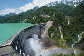
この北西(NW)の方角には富山県の黒部ダム、立山(雄山3,003m、大汝山3,015m、富士ノ折立2,999mの三つの峰)を越え、富山湾、七尾湾が位置しています。
立山は造山過程で山脈が東西に分かれ、立山連峰と後立山連峰からなります。黒部川を挟んで東側に位置する後立山連峰は七倉ダムの北に位置しています。
冬季の偏西風の強い寒気の影響により、日本海で発生した水蒸気が3,000m級の山々にぶつかることで大量の降雪が発生するなど、世界有数の豪雪地帯となっています。
黒部ダムは日本一となる186m堤高を誇り、堤頂長492m、毎秒10t以上の観光放水が圧巻。大町市からの立山黒部アルペンルートが代表的な観光ルートとなっています。
NW
To the northwest (NW), beyond Toyama Prefecture’s Kurobe Dam and the Tateyama Mountain Range (comprising three peaks: Mt. Oyama at 3,003m, Mt. Ohnanji at 3,015m, and Mt. Fujino-oritate at 2,999m), lie Toyama Bay and Nanao Bay.
The Tateyama range was divided into east and west by mountain formation processes, and consists of the Tateyama Range and the Ushiro-Tateyama Range. The Ushiro-Tateyama Range, located east of the Kurobe River, lies north of the Nanakura Dam.
Due to the influence of strong cold air from the westerlies during winter, water vapor generated over the Sea of Japan collides with the 3,000-meter-class mountains, resulting in massive snowfall. This area is one of the world’s snowiest regions.
Kurobe Dam, the tallest in Japan with a height of 186 meters, boasts a crest length of 492 meters, and its spectacular sightseeing discharge exceeds 10 tons per second. The Tateyama Kurobe Alpine Route from Omachi City is a representative tourist route.